

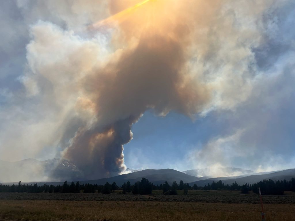
The Willow Fire is currently active in Lake County, and conditions across the Leadville and Twin Lakes area are changing frequently. If you have plans to be in the area, please take a few minutes to review the information below so you can stay safe, informed, and prepared. We update this page as new details come in.
Latest Update: 9/20/26
**Update to closure areas on 8/20/26 – the US Forest Service decreased the Willow Fire closure area, reopening Hagerman Pass, Windsor Lake Trail, Colorado Midland/Hagerman Tunnel Trail, Halfmoon Road (FS Road 110), North Elbert Trail.
Closures remain in place on Mount Massive Trail #1487, Highline/Native Lake Trail #1489, Willow Creek Trailhead, Colorado Trail #1776 (Segment 10).
Get your information from official channels
To make sure the information you have is accurate and current, rely on these official sources:
- Lake County Office of Emergency Management
- Evacuation and Pre-Evacuation Map
- Active Wildfire Information (Watch Duty)
- Current Fire and Smoke Activity (Purple Air)
- Local Webcams
- Blog Post – Leadville & Twin Lakes are Open: Your Adventure Awaits Beyond the Willow Fire
Closures, air quality, and business access can change from day to day, so please check these resources before and during your visit.
What is Open?
Many businesses, restaurants, and activities outside of the Willow Fire closure areas remain open and are continuing to welcome visitors. We encourage you to support our local businesses and enjoy what the Leadville-Twin Lakes area has to offer while staying informed and respecting all closures and safety guidance.
For outdoor recreation, we encourage visitors to explore areas to the:
- Northeast – Mayflower Gulch, Clinton Gulch Reservoir
- Northwest – Turquoise Lake Shoreline Trail, Timberline Lake Trail, Bear Lake, Colorado/Continental Divide Trail from Hagerman Pass Road (CR 4) to Halfmoon Road (FS Road 110), Colorado Midland Trail, Windsor Lake Trail, North Elbert Trail, Hagerman Pass
- East – Mineral Belt Trail, Mount Sherman, Route of the Silver Kings, Weston Pass, Mosquito Pass, Timberline Trails
- South – Interlaken Trail, Hope Pass, South Elbert Trail, Big Willis Gulch, Black Cloud Trail, Colorado/Continental Divide Trail
Please check current conditions before heading out and always follow posted closures and guidance from local officials.
Most of our indoor and outdoor businesses and activities:
- Mount Massive Golf Course – reopened on July 21st!
- Sugar Loafin’ Campground – reopened on July 21st!
- All 8 Museums
- Downtown Leadville restaurants, retail and lodging
- ATV tours
- The Leadville Railroad
- Top of the Rockies Zipline
- Twin Lakes recreation and businesses
Because conditions can change quickly, we recommend calling ahead before visiting a business or attraction. Some temporary changes may occur due to staffing well being, changing air quality conditions, or operational needs.
The following Turquoise Lake & Twin Lakes USFS campgrounds are also open (until September 20th):
- Dexter: first-come, first-served only
- Lakeview: by reservation or first-come, first-served
- White Star: by reservation or first-come, first-served
- Baby Doe – By reservation and first come/first serve
- Matchless – First come, first serve only
- May Queen – By reservation and first come/first serve
- Molly Brown – By reservation and first come/first serve
- Silver Dollar – By reservation and first come/first serve
Roads:
- All major highways in and out of Leadville and Twin Lakes are open including Hwy 24 (North & South), Hwy 91 and Hwy 82
What is Closed?
The following areas are closed until further notice:
In the Turquoise Lake Area
- South Turquoise Lake Road (CR 4) – from the Abe Lee Fishing Area (approximately 1 mile from the dam) to Hagerman Pass. Access to Abe Lee and Hagerman are allowed, closure is in between them.
- Native Lakes Trail
- Colorado / Continental Divide Trail section 11 in the Mount Massive Wilderness
Leadville Fish Hatchery Buildings and Trails
- Leadville Fish Hatchery
- Trails
- Nature Trail
- Kearney Park Trail
- Rock Creek Trail
- Highline Trail
In the Halfmoon Area
- The main Mount Massive Trail
- Willow Creek Trail
- Halfmoon Lakes Trail
- Colorado / Continental Divide Trail section 10
Here is a map showing the forest closure areas as of 8/20/26
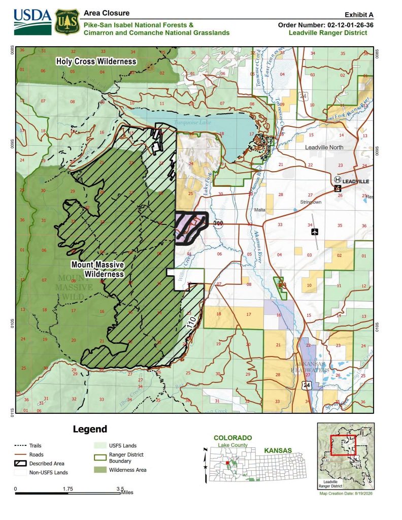
**LEADVILLE FISH HATCHERY REMAINS CLOSED**
List of closed trails:
- Native Lake Trail
- Rock Creek Trail
- Highline Trail
- Kearney Park Trail
- Willow Creek Trail
- Halfmoon Lakes Trail
- Colorado / Continental Divide Trail between Hagerman Pass Road (CR 4) and Halfmoon Road (FS Road 110)
List of closed roads:
- County Road 4 from Abe Lee Fishing Access Road (fishing access is open) to Hagerman Pass (pass is open)
- Forest Service Road 105
- Forest Service Road 110A & B
A note on camping
We are not encouraging dispersed camping at this time, as it can be difficult to communicate quick changes to people spread across the backcountry. If you are staying in the area, we ask that you book a local hotel or one of the USFS campgrounds listed above, where you can be accounted for and reached if conditions change.